Archaeology
Little Trees Hill (74m), part of the Gog Magog Hills, lies on Cretaceous Lower Chalk, having a glacial covering of boulder clay with underlying gravel currently excavated by badgers. A recent geological investigation into the glacial deposits exposed by the scrape on Little Trees Hill, concerns rhomb porphyry, a somewhat rare and distinctive rock brought, along with other rock deposits, by glaciers from the Oslo Rift in Norway and potentially deposited on the Hill. This was featured in a film by Marian Holness of Trinity College Cambridge and highlights the cobbles in the roadway at the entrance to Trinity College. The short film is available to watch here.
The region has been grassland probably since prehistoric times and was famous for extensive sheep walks until well into the 19th century. The Icknield belt of open heath stretched across relatively dry chalkland between the Fens and the Chilterns. It provided a well-used thoroughfare linking Cambridge to Norfolk and the South. Neolithic axes were taken from Grimes Graves to Wessex.
3000 – 2400 BC Middle Neolithic
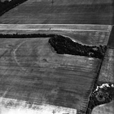
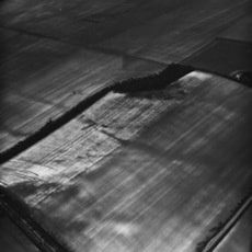
Aerial photography from the 1950’s through to 1984 indicated the possible presence of a Neolithic Causewayed Enclosure coincidental with the 65 m contour of Little Trees Hill though partially eroded by ploughing, but generally in good condition. That on Little Trees Hill has the characteristic segmented ditch and is around 265m in diameter. This was constructed with internal and external banks with a 4m deep ditch in mostly 10 to 15 m segments. One longer ditch section of 30m has been identified. A trackway, NW to SE, on northeast side partially converges with the enclosure.
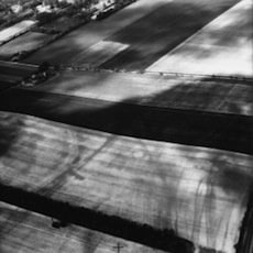
Aerial Photographs courtesy of University of Cambridge Unit for Landscape Modelling.
© Copyright reserved
2400 – 1500 BC Late Neolithic to Late Bronze Age
Further evidence of Neolithic and Early Bronze Age activity was revealed by surveys carried out by the Cambridge Archaeology Field Group in 1979/80 and 1990/91, which identified a distribution of flint tools and manufacturing debris. Summary reports are available here. A Neolithic flint arrowhead was found in 1970.
A Bronze Age Bowl Barrow is present near the summit of Little Trees Hill (formerly Clunch Pit Hill). As a result, this area was scheduled as an Ancient Monument by English Heritage in 1994.
During 2008 and 2009 the local Archaeology Research Group conducted Magnetometer Surveys of the area around the Bowl Barrow. Their findings indicated a possible ditch line.
This work led to English Heritage arranging a topographical survey of the scheduled area by Northamptonshire Archaeology. This has confirmed the presence of the enclosure and ditch surrounding the Bowl Barrow.
The significance of the monument is enhanced by its association with an adjacent trackway, which will allow the relationship between the enclosure and its setting to be analysed over time; and by the presence of a bowl barrow within the interior which represents the continuation of the site’s use into the Bronze Age period.
Funding was made available from Cambridge County Council, English Heritage and Natural England for shrub and tree clearance on and around the Barrow and protective fencing along the top of the quarry. This and future work will ensure the survival of these ancient remains for future generations.
1900s
The Army Manoeuvres of September 1912 were one of the last peacetime military exercises before the outbreak of war. Advancing from Cambridge to Linton, the Red army, under the command of General Haig, were defeated by the defending Blue army directed by General Grierson. Borrowing Marshal Bosquet’s comment of the Charge of the Light Brigade, the New York Herald described the 1912 manoeuvres as ‘magnificent, but it was not war’, although lessons learned from this mobilisation later crucially informed Haig’s first wartime encounters. [https://en.wikipedia.org/wiki/Army_Manoeuvres_of_1912]
In 2008, the community group Archaeology Rheesearch carried out a geophysical survey of a reported crop mark on Magog Down. They identified a vertically sided deep square feature, about 15m across. They have postulated that the feature may be a temporary structure associated with pre WWI military exercises and possibly the 1912 Army manoeuvres. The geophysical survey has determined the location and dimensions but an archaeological excavation could resolve the date and purpose of this feature. A similar feature has been identified by aerial photography on the neighbouring golf course. Further information is available in the Archaeology Rheesearch Group report.

Map of scheduled monument
Farming
Moor or Heath field comprising Wandlebury, Gog Magog and Heath Farms and Little Trees Hill was recorded as 500 acres in the 13th century and 547 acres in 1740. The Lords of Sternes, a manor in Stapleford, had a demesne sheepwalk and copyhold each for 500 sheep. The area was ploughed to improve pasture c1720 and c1810 by sowing of grass seed despite opposition from the Dean and Chapter, who always claimed sole ownership of the heath and sheepwalks. The land was divided in 1741 between the Dean and Chapter and Lord Godolphin, each receiving 274 acres with sheepwalks for 300 animals.
Enclosure map
With enclosure in 1812 a lot of chalk grassland was ploughed for arable use, but sheep were still present.
- 1814 Gog Magog Farm had 200 Sussex sheep
- 1885 Gog Magog Farm kept 1060 grown sheep
- 1905 Gog Magog Farm kept nearly 500 sheep
- 1977 one farm had almost 350 sheep
The area under grass more than doubled from 176 acres in 1885 to 417 acres in 1905 through partial conversion of Heath Farm to a golf course.
An extensive plantation was laid out around the hilltops in the mid to late 19th century. From 1894 wheat, barley and until the 1920s, oats, remained the principal crops.

Clunch Pits
An interesting man-made feature of the landscape of South Cambridgeshire is the cluster of clunch pits dug into the sides of the low chalk ridges bordering the upper Cam valley and along the Fen edge towards the Suffolk border. These quarries were hewn by hand from the chalk outcrops. The extracted ‘clunch’ was used as a building material from medieval times up to the end of the nineteenth century often in the construction of churches and the Cambridge colleges.
A large quarry exists on Little Trees Hill though when it was started is unknown. A smaller one, known as Stapleford Parish Pit was the most recent to be used and is believed to have acted as a rubbish dump in the last years of its use and workings ended in the 1930s.
Latterly, restoration has taken place in this pit and it is now a haven for wildlife and flowers, many chalk indicator species. The Stapleford Pits are significant in the wider landscape as one of many former chalk quarries in villages across the county, that are now a network of chalk grassland fragments.

Stapleford Parish Pit

Little Trees Hill eastern clunch pit after scrape in 2019
The Cambridge botanist Charles Babington in 1861 recorded “Anemone pulsillata in beauty and great abundance in the pit at Little Trees Hill.”
By felling several sycamores, removing the ground vegetation and stripping the organic layer of soil from the floor of Little Trees Hill eastern pit it is the intention of The Trust, to recreate calcareous grassland including the Pasque flower. This development was recommended by the local Wildlife Trust in a report on ‘Management Suggestions for Magog Down, 2008’ and carried out in 2019.
